<?xml version="1.0" encoding="utf-16"?>
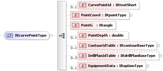
<xsd:complexType name="IRcurvePointType">
<xsd:annotation>
<xsd:documentation>Curve point data type</xsd:documentation>
</xsd:annotation>
<xsd:sequence>
<xsd:element name="CurvePointId" type="IRtextShort" minOccurs="0">
<xsd:annotation>
<xsd:documentation>Points id numberReference id for a specific tunnel line point.</xsd:documentation>
</xsd:annotation>
</xsd:element>
<xsd:element name="PointCoord" type="IRpointType">
<xsd:annotation>
<xsd:documentation>Point's coordinates</xsd:documentation>
</xsd:annotation>
</xsd:element>
<xsd:element name="PointG">
<xsd:annotation>
<xsd:documentation>The inclination angle. See definition of inclination angle in "IREDES coordinate system description" document. UNIT: degree</xsd:documentation>
</xsd:annotation>
<xsd:simpleType>
<xsd:restriction base="IRangle">
<xsd:minInclusive value="-90.000" />
<xsd:maxExclusive value="90.000" />
</xsd:restriction>
</xsd:simpleType>
</xsd:element>
<xsd:element name="PointDepth" type="xsd:double" minOccurs="0">
<xsd:annotation>
<xsd:documentation>Point's depth in tunnel along tunnel line. Unit: meter</xsd:documentation>
</xsd:annotation>
</xsd:element>
<xsd:element name="ContourIdTable" type="IRcontourBaseType" minOccurs="0">
<xsd:annotation>
<xsd:documentation>Contour Id table consists of a set of corresponding contours Id's</xsd:documentation>
</xsd:annotation>
</xsd:element>
<xsd:element name="DrillPlanIdTable" type="IRdrillPlanBaseType" minOccurs="0" maxOccurs="3">
<xsd:annotation>
<xsd:documentation>Drill plan Id table is a set of corresponding drill plan Id's. Up to three drill plans can be referenced, e.g., for blasting, bolting and injection.</xsd:documentation>
</xsd:annotation>
</xsd:element>
<xsd:element name="EquipmentData" type="IRoptionType" minOccurs="0">
<xsd:annotation>
<xsd:documentation>Specific data depending on manufacturer and equipment</xsd:documentation>
</xsd:annotation>
</xsd:element>
</xsd:sequence>
</xsd:complexType>
|